LOTS 8 & 10
agency logo

Lots 8 & 10, 5 Dennes Road, Barnes Bay TAS 7150

Land
Block size: 2900 m² approx.

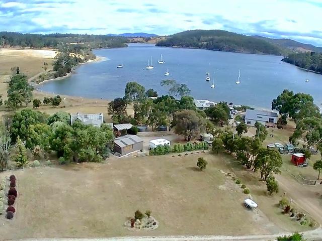
Last chance to secure residential land in this quiet and sheltered Bruny Island haven

Lot 7 - SOLD
Lot 8 3059sqm $255,000
Lot 9 - SOLD
Lot 10 - 4267 sqm $320,000
Lot 11 - SOLD

These blocks are the last parcels of quality residential land likely to be available in Barnes Bay on North Bruny Island.

The gently-sloping lots all enjoy sheltered and sunny positions, with lovely views down to Simmonds Cove. This quiet corner of Barnes Bay is one of the very few all-weather anchorages on Bruny Island, just a short cruise across the D'Entrecasteaux Channel from the marina in Kettering or a pleasant half-day sail down the River Derwent from Hobart.

Ranging in size from 2690m 2 (lot 7) to 3059m 2 (lot 8), the land comprises a mix of pasture and attractive light bush with some mature eucalypts providing habitat for abundant birdlife. All blocks offer excellent building sites to maximise the sunshine and views.

Barnes Bay is only 15 minutes' drive from the ferry terminal at Roberts Point. It is a quiet and peaceful spot that avoids the increasing tourism traffic at many other locations on the island. The shoreline of Simmonds Cove is only a couple of minutes' walk away - this is the perfect spot to launch a dinghy or kayak or to anchor your cruising yacht in the bay.

Titles for all lots have been issued. Don't miss out on this rare opportunity to own and build on your special piece of Bruny Island. Please contact Jude to arrange an inspection.

*The information contained herein has been supplied to us and we have no reason to doubt its accuracy, however, cannot guarantee it. Accordingly, all interested parties should make their own enquiries to verify this information.

Inspections

No open inspections scheduled.

Send an enquiry

Contact Jude Viney to learn more about this property, request an inspection or take an online tour.

Key details

Property type:
Land
Block Size:
2900 *

Other Details

Fall Real Estate Hobart

Maps and area information

Block information
Block size: 2900 (approx)
Block Map
No block information available
Measurements are estimates only and based on data provided under licence from © PSMA Australia 2024.
Sorry, overlays are not available for this address
Need more info? We've got you covered.
A block's planning zone defines how that land can be used and what can be built on it.
A right to use a part of land owned by another person for a specific purpose. The most common forms of easements are for services, such as water, electricity or sewerage.
The value of a block of land without any buildings, landscaping, paths, or fences. This is different to the block's market value. A block's unimproved value is used to calculate rates and land tax charges.
This represents the shape of the geographical land. Closely spaced contour lines represent a steep slope. Widely spaced lines represent a gentle slope.
Enrolment areas for ACT public schools.

What's nearby

Snug Primary SchoolPrimary School
10.7km
Woodbridge District High SchHigh School
11.4km
Kingston Tas EverydayMajor Shopping Centre
15.9km
St Aloysius Catholic CollegeCollege
14.7km
Australia PostPost Office
9.5km
Tafe - Kingston CentreTafe
16.2km

Property history

We couldn't find any history for this property.
See Barnes Bay's suburb profile

Barnes Bay suburb information

A little bit about who lives locally, as provided by government census data
SummaryMedian sales
Average Age
72 years
Population
28
Listing ID: 181562171. This listing has been viewed 33 times. It was first displayed on 26/04/2023 and last updated on 27/02/2024.
Allhomes acknowledges the Ngunnawal people, traditional custodians of the lands where Allhomes is situated. We wish to acknowledge and respect their continuing culture and the contribution they make to the life of Canberra and the region. We also acknowledge all other First Nations Peoples on whose lands we work.
"With open hearts and minds, together we grow." artwork by David Williams of Gilimbaa.